

Hey everyone,
I have a pretty specific question.. does anyone know where I can find a full picture of the Detroit map on the Motown record label, but without the rainbow Motown label?
I tried looking for vintage maps but to no avail... thanks in advance!
![]()
![]() HEADLINE TOPICS
HEADLINE TOPICS
![]() SOULFUL DETROIT Forum
SOULFUL DETROIT Forum
![]() MOTOWN Forum
MOTOWN Forum
![]() CLUBHOUSE
CLUBHOUSE
![]() ALL FORUMS
ALL FORUMS
![]() Forum Archives
Forum Archives
![]() Soulful Detroit Tours
Soulful Detroit Tours
Results 1 to 14 of 14
Thread: Detroit map on Motown labels?
-
07-20-2018, 01:11 PM #1
 Junior Member

- Join Date
- Jul 2018
- Posts
- 1
- Rep Power
- 0
Detroit map on Motown labels?
-
07-20-2018, 07:50 PM #2
Senior Member


- Join Date
- Aug 2010
- Posts
- 2,186
- Rep Power
- 247
I hate to say it, but I think you are looking for a "Needle in a Haystack." Regretfully I have never ever seen one. Hopefully someone will prove me wrong.
-
07-20-2018, 09:03 PM #3
Senior Member
- Join Date
- Sep 2016
- Posts
- 6,825
- Rep Power
- 257
I know this is not at all helpful, but can I just say how much I love that Motown logo!

-
07-21-2018, 03:34 AM #4
Senior Member
- Join Date
- Aug 2010
- Posts
- 14,986
- Rep Power
- 404
Given it's scale, I would guess it is showing the Michigan, Ohio, Southern Ontario portion of a Petroleum Company's Gas Station giveaway map, or AAA driver's folding map of The entire USA from the early 1960s. The State of Michigan is too small for it to be an individual state map of Michigan, and way too much of an area is shown for it to be a map of The Detroit Metropolitan Area. Yet, not enough is shown for it to be all of North America.
It's exactly the scale of the gas company and AAA driving folding maps of USA. Actually, when I was young, i compared such maps to the map on the label, and the areas of southern Michigan and northern Ohio matched up, exactly. Those maps were made by Rand, McNally & Co. The map on the label can be matched up by the run of maps that used contour lines on the outer edges of lakes and the oceans. Of course, the big star atop Detroit was put there by Motown, and was not on Rand, McNally's maps.
-
07-21-2018, 07:01 AM #5
Senior Member
- Join Date
- Aug 2010
- Posts
- 11,552
- Rep Power
- 295
Eh...are you sure you didn't just post an error? Michigan is a fairly big state. Originally Posted by robb_k

-
07-21-2018, 12:04 PM #6
Senior Member
- Join Date
- Aug 2010
- Posts
- 43,221
- Rep Power
- 600
Robb, when I was a kid, I use to stare at the map until I figured out that Toledo was under the "O" in the picture. LOL! Originally Posted by robb_k
-
07-21-2018, 12:49 PM #7
Senior Member
- Join Date
- Aug 2010
- Posts
- 14,986
- Rep Power
- 404
Originally Posted by soulster
I really don't think so. No way the Michigan State Map would show such a big portion of Ohio, on such a small portion of the overall map size. The Michigan state map had northern Michigan on one side, and southern Michigan on the other. It had much, much, much more detail than the map on The Motown label. I'd bet the farm it is The USA highway map. It can't really be anything else. The state maps highway number boxes would be bigger, and there'd be a lot more detail and small roads, even some dirt roads show up in The Boonies.
I still have several of them, plus all the US state and city maps stored in USA, in my sister's garage. When I go there in November, I'll check it against a Motown label, then, and prove it.
Last edited by robb_k; 07-21-2018 at 02:57 PM.
-
07-21-2018, 12:57 PM #8
Senior Member
- Join Date
- Mar 2012
- Posts
- 4,735
- Rep Power
- 316
Ha ha!
You are something else robb k!
[[In a good way!)
😎
-
07-22-2018, 03:52 PM #9
Senior Member
- Join Date
- Aug 2014
- Posts
- 4,108
- Rep Power
- 247
I'm afraid I can't answer your question, either, lucyl, but, if memory serves, didn't the early Motown map label change from showing a map of Detroit to a map of Michigan? Your mention of a "Detroit map" made me think of it.
-
07-23-2018, 05:17 AM #10
Senior Member
- Join Date
- Aug 2010
- Posts
- 2,282
- Rep Power
- 189
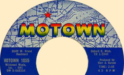
From the site Both Sides Now dedicated to US LP's : http://www.bsnpubs.com/motown/motown/motown.html Originally Posted by Philles/Motown Gary
"The second Motown label was dark blue on the bottom 2/3 of the label with printing in silver. The top 1/3 of the label had a map of the United States extending from the Atlantic to the western edge of Kansas, with a red star at Detroit, Michigan, on the right side of the map."
"The fourth Motown label [[near left) has the bottom 2/3 dark blue, a map of the United States extending from mid-Indiana to mid-Pennsylvania, smaller red star at Detroit [[on the left side of the map)"
Here's the second label :
and the fourth label
"
-
07-23-2018, 03:39 PM #11
Senior Member
- Join Date
- Aug 2014
- Posts
- 4,108
- Rep Power
- 247
Hey, thanks so much, Phil! Quite a contrast between the two! Of course, the latter is the beautiful version that we Americans know and love.
-
07-23-2018, 03:50 PM #12
Senior Member
- Join Date
- Aug 2010
- Posts
- 2,282
- Rep Power
- 189
You're welcome PMG !
-
07-23-2018, 03:51 PM #13
Senior Member
- Join Date
- Aug 2010
- Posts
- 14,986
- Rep Power
- 404
I don't remember any street map of Detroit being used. They were all major road maps of USA.
-
07-23-2018, 04:08 PM #14
Senior Member
- Join Date
- Aug 2014
- Posts
- 4,108
- Rep Power
- 247
You're probably right, Robb. Whatever I thought I had once read, I must have remembered wrong. My sense of direction and geography is the pits anyway! Originally Posted by robb_k

 Reply With Quote
 Posting Permissions

Soulful Detroit Navigation
SoulfulDetroit Management
SoulfulDetroit Affiliates
© AtDetroit LLC All Rights Reserved - unless otherwise specified. Please notify us of uncited proprietary content.
Bookmarks